Good so now this gives me another opportunity to provide an update on the state of the monsoons. I hereby reveal that I am actually a staff at the Indian Met Department but have a junior rank. However what I try to do is do my job dilligently collecting infromation, studying data and being honest with my job. My bosses however are busy warming their chairs, hardly monitoring any trends and are only painting a rosy picture day in day out to please their political bosses who earn by playing the stock markets. Remember the IMD passed similar predictions for the monsoons during end of May and was super confident that June will receive normal rainfall. We already have seen the results with the key granary states having received 60% or even lesser rains till June.
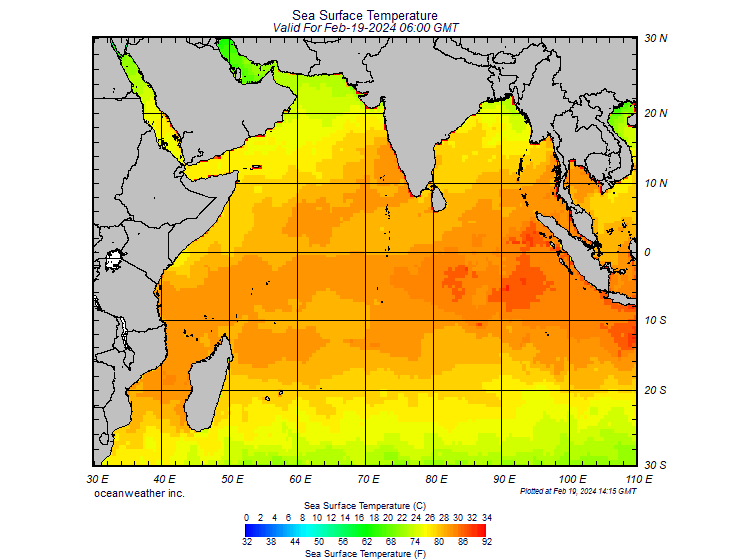
Here is my next unofficial update which my bosses either don't know about or won't share. The Australian Bureau of Meterology has stated today that El Nino is happening. All the El Nino and the Southern Oscillations readings point to a strong El Nino season during winter. Sea surface temperatures have climbed 0.4 degrees in a matter of 2 weeks in the Pacific ocean !! How does these affect Indian monsoons? I will try to keep it less technical. We all know from our standard physics & geography classes that for monsoons to happen cold air from the Indian ocean travels to the Indian continent from the south west as summers in India warm up the air and create a low pressure situation. That is why it is called south west monsoon. Now what happens if the Indian ocean is itself very warm compared to the Indian subcontinent? The sea surface temperatures as it happens now in the Indian ocean is unusually high which is creating a low pressure situation in those areas instead. This prevents the flow of cold moisture laden air from those areas into the Indian subcontinent. In fact water vapor is being transferred from the Indian subcontinent into the seas. Why are the sea surface temperatures high in Indian ocean? This is because of the developing El Nino and for another phenomenon called the Indonesian Throughflow. The Indonesian Throughflow is the flow of warm water from the equatorial south east Asian seas and the western Pacific ocean. During a La Nina year this flow of warm water into the Indian ocean is low because La Nina causes the Pacific ocean to be colder hence most of that warm water from the Indonesian Throughflow go towards the Pacific. But during El Nino years when the Pacific ocean waters are warmer, most of the Indonesian Throughflow dumps a lot of warm water into the Indian ocean and that is why the sea surface temperatures are very high now which in turn weakens the monsoon greatly.
Here is the proof.

QED. All this is scientific analysis based on publicly available information but my bosses in the Indian met department are idiots. Hope our nation can realize this danger soon. I will continue posting more updates as things unfold for the month of July and August. Say hello to Hyperinflation 2012.
Here is my next unofficial update which my bosses either don't know about or won't share. The Australian Bureau of Meterology has stated today that El Nino is happening. All the El Nino and the Southern Oscillations readings point to a strong El Nino season during winter. Sea surface temperatures have climbed 0.4 degrees in a matter of 2 weeks in the Pacific ocean !! How does these affect Indian monsoons? I will try to keep it less technical. We all know from our standard physics & geography classes that for monsoons to happen cold air from the Indian ocean travels to the Indian continent from the south west as summers in India warm up the air and create a low pressure situation. That is why it is called south west monsoon. Now what happens if the Indian ocean is itself very warm compared to the Indian subcontinent? The sea surface temperatures as it happens now in the Indian ocean is unusually high which is creating a low pressure situation in those areas instead. This prevents the flow of cold moisture laden air from those areas into the Indian subcontinent. In fact water vapor is being transferred from the Indian subcontinent into the seas. Why are the sea surface temperatures high in Indian ocean? This is because of the developing El Nino and for another phenomenon called the Indonesian Throughflow. The Indonesian Throughflow is the flow of warm water from the equatorial south east Asian seas and the western Pacific ocean. During a La Nina year this flow of warm water into the Indian ocean is low because La Nina causes the Pacific ocean to be colder hence most of that warm water from the Indonesian Throughflow go towards the Pacific. But during El Nino years when the Pacific ocean waters are warmer, most of the Indonesian Throughflow dumps a lot of warm water into the Indian ocean and that is why the sea surface temperatures are very high now which in turn weakens the monsoon greatly.
Here is the proof.